Hauraki and Coromandel Marine Protection Areas Proposed by DOC
Written by John Grant on October 11, 2022
The Department of Conservation is seeking feedback on Government proposals for increased marine protection of the Hauraki Gulf extending around the Coromandel to include areas such as the Alderman Islands, Cape Colville and extending the current marine reserve around the Cathedral Cove area.
The justification for this has been reports illustrating that the Gulf is in an ongoing state of environmental decline due to human activities. DoC say in the report that pressures from harvest and utilisation activities, land-based activities (e.g. pollution and sedimentation) and climate change have contributed to a decline in coastal and marine biodiversity. Increasing prevalence of ecosystem changes such as kina barrens, habitat loss and localised fisheries depletion are some of the ways these issues are manifesting.
Doc says in the proposal that national and international experts consider area-based marine protection to be one of the most effective methods for protecting marine life. In the Gulf at present, there are six existing marine reserves and four cable protection zones (CPZ) that are recognised as ‘Type 2’ marine protected areas. These cover 0.28% and 6.3% of the Gulf respectively. The protection areas proposed would increase protection to 18% of the Gulf (including the CPZ) and according to DoC, bring us closer to creating an effective network of marine protection.
You can access a copy of the report document here.
What is being proposed?
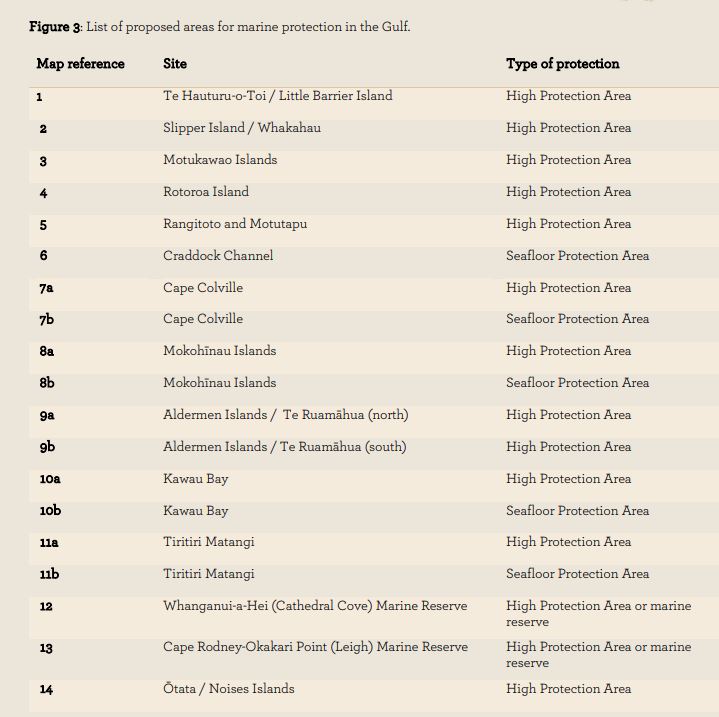
Doc has proposed establishing 19 new protected zones in the Hauraki Gulf, using two new marine protection tools established through new legislation (a new Hauraki Gulf Marine Protection Bill). They say that this increase in marine protection will support the recovery of some of the most biodiverse regions in the Gulf. The proposed marine protection package includes:
- 12 High Protection Areas (HPAs) to protect and enhance marine habitats and ecosystems while providing for the customary practices of mana whenua;
- 5 Seafloor Protection Areas (SPAs) to protect sensitive sea floor habitats while continuing to allow for compatible activities; and
- 2 protected areas adjacent to Whanganui-a[1]Hei (Cathedral Cove) and Cape Rodney – Okakari Point marine reserves. These areas will be established as HPAs or marine
reserve extensions.
Anyone can provide feedback by emailing DoC at: [email protected]. Please ensure any attachments are in either a PDF or Microsoft Word format and include your name (or the name of the group you are representing) and contact details in your email.
The following table refers to the picture above and explains the type of protection for each area.
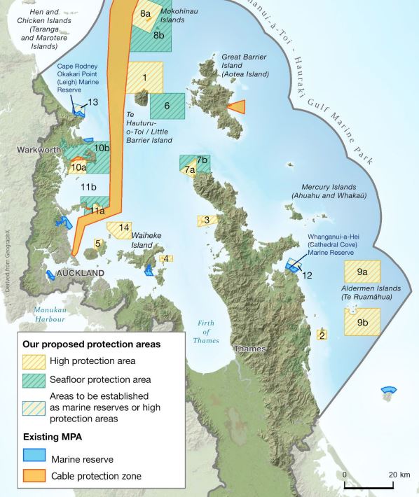
Picture :DoC – Proposed Marine Protection

John Kosar On December 19, 2022 at 8:37 am
I’m struggling with the idea of having a “high protection area” or reserve that people can go into and fish and dive …. While driving past other people who can’t …. In my mind a protected area is protected from all otherwise it isnt protected at all just someone’s private fishing and diving area …. Just saying 😊
Tim Harper On August 14, 2023 at 1:20 pm
Hi hard to tell the island the boundaries on area 3 which island by names are affected eg bush rabbits elephant and bush and double that are the local name
Also what are the boundaries on land
I see it is coliville harbour in the north but how far south towards papa Aroha thank you
Peter Dellaway On October 30, 2025 at 2:52 pm
Dont mind marine areas being set up but everyone recreational- customary practices- commercial kept out if its good for one its good for all how do you think recreational people will fell seeing others use it while they are banned