Te Aroha’s shaky start to the year
Written by John Grant on January 19, 2023
A strong earthquake occurred at 5:39AM on Wednesday 4 January, 5km south of Te Aroha, making for a shaky start to the year for residents and holidaymakers at the top of the north.
GNS Science received over 20,000 felt reports from the M5.1 quake which was preceded by a M3.9 five days before and followed by a M3.9 aftershock a few hours later, and no doubt made for a rude awakening for a region largely unused to seismic activity. Still, even in areas that don’t experience regular shaking, earthquakes shouldn’t come as too much of a surprise.
Though being an area of low seismicity, Te Aroha lies near the Kerepehi Fault, which is part of the Hauraki rift zone and has experienced strong shaking in the past. In New Zealand, land of the shaky isles, the rule of thumb is clear – earthquakes can happen anytime, anywhere, and no region is exempt.
GNS Science works hard to learn all it can about every earthquake and uses that knowledge to help local emergency management teams and the National Emergency Management Agency in their work to keep our communities earthquake ready.
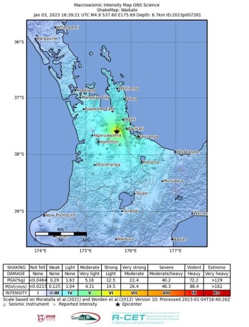
So, what have we learned about Te Aroha’s quake? GeoNet’s shaking layer reveals the detail.
“Shaking from the M5.1 mainshock reached up to moderate and strong levels, with a maximum Modified Mercalli intensity of 6,” says Seismic Hazard Modeller, Dr Tatiana Goded.
“Our analysis of an event’s shaking impact is helped significantly by the Felt Reports submitted by the public. For the M5.1 we received over 20,000 Felt Rapid reports and nearly 1,000 Felt Detailed reports. The especially valuable Felt Detailed data is added to the Shaking Layers map to provide extra detail.”
“We really value the information the public provides us in the Felt Detailed reports, particularly in the regions close to the epicentre. With this particular event the public-sourced information increased the number of observations seven-fold compared to what we could access just by using our scientific instruments,” Dr Goded said.
The impact on the ground
Ground cracks were reported in a farmer’s field around Te Aroha, 5 kilometres away from the epicenter. GNS Science Earthquake Geologist, Dr. Pilar Villamor, has been working with her colleagues to understand more about what the land damage can tell us about the earthquake.
“The cracks are only a few metres long and are located close by, and parallel to the creek banks. They are likely to be the result of lateral spreading.” “Geotechnical engineers have visited the site and their work will confirm the origin of the cracks,” explained Dr Villamor.
“As far as we can tell, they do not seem to be related to fault rupture and may be just a result of soils losing cohesion as a consequence of the strong shaking.”
Satellite-based radar, InSAR (Interferometric Synthetic Aperture Radar) is commonly used to monitor surface deformation, but there was no clear signal related to this event.
“This is consistent with the earthquake parameters,” says InSAR Scientist, Dr. Ian Hamling.
“We wouldn’t expect significant deformation for an earthquake of this magnitude, depth and location.”
Experts unite! The collaborative seismic science effort
The old adage ‘it takes a village’ is certainly applicable to natural hazard science and response. Many organisations and agencies have a role to play in event response and in the science and research that underpins our monitoring and preparedness. Excellent networking and good working relationships between teams is a must, as George McQuillan, Regional Resilience Advisor for the Waikato Regional Council, explains.
“What’s really neat about (the Te Aroha earthquake event) is how quickly we were able to pull together the right people from across different agencies and organisations to investigate and analyse the reported deformation,” he said. “We’re extremely fortunate to have our own geoscience, geotech, and data science expertise within the Waikato Regional Council team and, through our work with GNS on paleoseismic studies, we were able to just jump on the phone and talk to the right people, straight away.”
“We also have strong connections with geoscientists and engineering staff at the University of Waikato, giving us access to even more expertise and some pretty fancy surveying and remote sensing gear.”
Earthquakes don’t respect public holidays and festive seasons, but events that occur outside of business hours still need to be managed. Luckily, the science community is willing and engaged, and the collaborative science effort is readily activated.
“The Te Aroha quake served as a timely reminder of how important our relationships and collaborations are when events happen,” McQuillan reflects.
“It was the holidays and most people were on leave, but everyone that was contacted didn’t hesitate to jump on board!”
You too can get involved in Aotearoa New Zealand’s seismic science
The GeoNet App keeps you updated on earthquakes, volcanoes and geohazard news. It gives details of all earthquakes located in and around New Zealand within just minutes of them happening. The app enables you to set up notifications of earthquakes close to your current location (using your phone’s GPS), or you can opt to receive alerts for multiple locations and earthquake intensities around the country.
If you feel an earthquake, you can submit a Felt Report on the app, which helps the science team understand more about the ground shaking. If you would like to complete a more Detailed Felt Report, please go to our website. Felt Reports are great for helping scientific responders understand the impact of the event, and the information can be fed into tools like the shaking layers map.
You can also read our latest news and keep updated on volcanic activity on the app, and those that wish to can view peak ground accelerations (PGA) and velocities (PGV) recorded by our seismograph network.
Download the app now on your Android and iOS devices: Google Play for Android and The App Store for Apple.
When you notice damage that you think may be related to an earthquake, like ground cracking and landslides, you can report it to the local Regional Council. Your observations might just help fill any gaps in the earthquake’s story.
Reader's opinions

Continue reading